


Automated shading and roof detection is growing fast in the solar industry because it saves time, reduces risk and delivers far better accuracy than traditional surveys.
If you have ever climbed a roof with a tape measure, you already know how tiring and uncertain those measurements can be. Drone AI workflows solve most of these issues with a simple flight that captures the entire structure in minutes.
Drone AI integrations automate roof detection, shading analysis, and 3D modeling with a mix of photogrammetry and computer vision. EPCs get accurate layouts, safer surveys, faster feasibility checks, and data rich digital twins, which reduce field visits and improve design accuracy for commercial, industrial, and residential projects.
As more EPCs move to commercial and industrial markets, the demand for fast surveys and precise shading data keeps growing. Drone AI makes these early steps smoother and helps teams design stronger systems with fewer site visits. This is why automated shading and roof detection is becoming a new normal for modern solar companies.
Drone solar surveying is growing across all segments because it solves problems that have slowed solar teams for years. The rise of C&I rooftop solar plays a major role in this trend. These roofs are large, cluttered, and tricky to measure with manual methods. A drone flight captures them in a few minutes and delivers clean measurements to the design team.
Safety has also improved in a big way. Surveyors do not need to climb steep roofs or walk close to edges to collect basic details. A simple automated flight plan keeps the entire team on the ground while still capturing everything that matters.
Drone AI mapping also speeds up presales assessments. Sales teams no longer wait days for site visits or measurements. They can run a quick drone survey to confirm feasibility and prepare a proposal much faster.
The precision of AI mapping solar workflows is another major advantage. Manual tape measurements are often off by a few inches but drones consistently deliver sub-inch accuracy. This accuracy becomes even more important for C and I buildings where small mistakes can affect financial models.
Compatibility with cloud-based solar design tools has pushed adoption even further. Most platforms now allow point cloud or orthomosaic uploads, making it easy for designers to start working right away.
This is why drone AI surveying has become one of the fastest-growing trends in solar today.
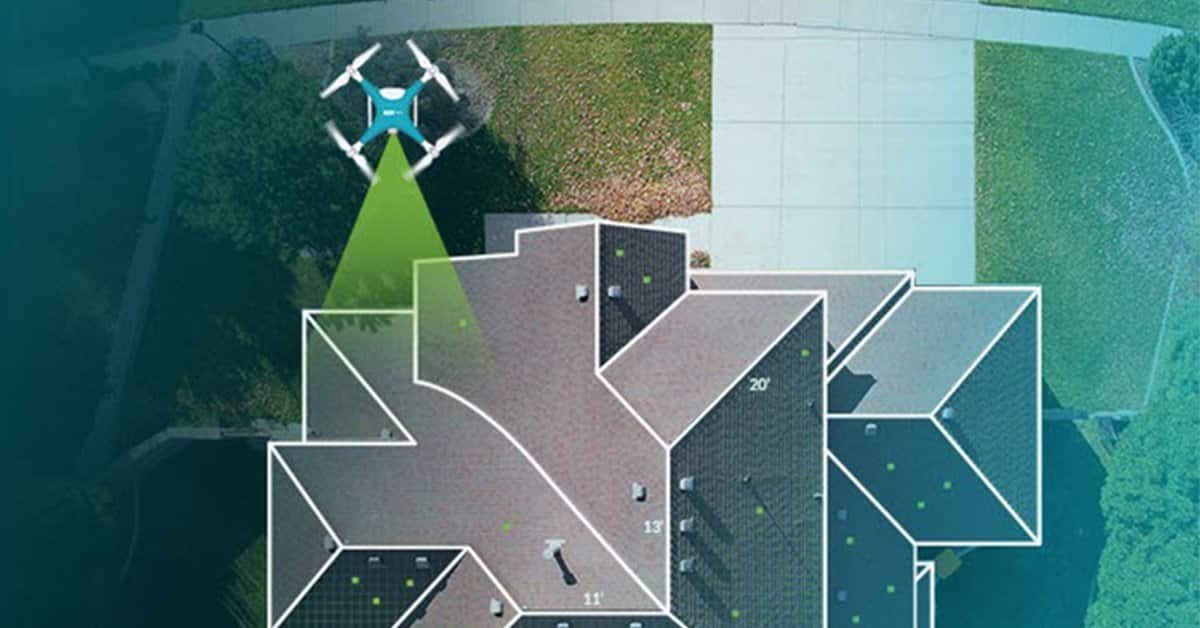
The process starts with an automated drone flight. The operator selects the roof area and the drone follows a set path to capture clear images from different angles. The drone collects high-resolution and oblique-angle photos that highlight roof surfaces and edges. Since everything happens in the air, there is no need for ladders or tape measures.
All captured photos are then processed through a photogrammetry engine. This engine converts hundreds of images into a 3D point cloud that represents the entire roof. The system also creates a mesh model and an orthomosaic image, which helps designers and engineers understand the roof in great detail.
Once the 3D model is ready, the AI engine takes over. It identifies roof planes, slopes, ridges, valleys, and the shape of each section. It measures total roof area along with usable space. The AI also detects vents, skylights, HVAC units, and other obstructions that affect panel placement. This gives the designer a complete picture of what is possible on the roof.
The engine then draws placement boundaries. It sets setbacks based on local codes, marks fire paths, and outlines every usable solar zone. This step takes a fraction of the time a designer would need if done manually.
This four-step workflow produces consistent results for any site and forms the base for an accurate solar layout.
Automated shading analysis begins with 3D object detection. The AI engine identifies all shading elements, including trees, parapet walls, nearby buildings, and rooftop equipment. Since the drone captures everything in detail, the shading model becomes far more accurate than satellite based tools.
Once the objects are mapped, the system runs an annual shading simulation. It checks how shadows fall on the roof each hour of the year. It also considers seasonal changes in sun angles which helps designers understand real-world losses. This is especially important for C and I roofs where obstructions are common.
AI tools also generate a horizon profile using the drone derived skyline. This includes faraway buildings or natural features that might affect morning or evening production. When all these shading layers come together, the designer receives a complete picture of how the site will perform. This leads to stronger yield estimates and more reliable financial modeling.
Drone surveys offer clear advantages over manual or satellite-based approaches. Precision is the first major benefit. Manual measurements can vary from person to person but drones deliver sub-inch accuracy that does not change between sites or teams.
Time savings are also significant. Solar surveyors spend hours measuring a roof with tape or wheel tools. A drone maps the same site in around twenty to thirty minutes.
Safety improves because nobody needs to climb a ladder or walk across fragile roofs. Everything is done from the ground using an automated flight plan.
The completeness of the model is another major advantage. The AI detects every vent, pipe, skylight, parapet, and obstruction, even when they are small. Satellite images often miss these details and manual surveys miss them if the team cannot access that part of the roof.
Finally, drone surveys offer consistency. Large EPCs can standardize their survey operations across multiple regions and avoid differences caused by local teams or varying skill levels. This makes the design workflow faster and more predictable across the entire organization.
Drone data is not only for early surveys. It also helps create a full digital twin of the site. A digital twin is a detailed 3D model that behaves like the real building. When geometry and shading data from the drone are merged, designers get a realistic view of how the system will perform.
A digital twin also lets EPCs simulate different layouts and compare their performance. Since shading impacts are high resolution, the yield model becomes more accurate. Financial predictions such as P50 and P90 results are stronger because they rely on real measurements instead of assumptions.
During installation, the digital twin becomes even more useful. Field crews can check placements, confirm dimensions, and avoid mistakes. It also helps with quality checks after installation because crews can compare the built system with the digital reference model.
This level of accuracy helps teams reduce change orders and improve customer satisfaction.
Modern cloud-based solar platforms make it easy to upload point clouds, meshes, and orthomosaics. The system automatically recognizes building shapes so designers do not need to redraw everything from scratch. This saves a lot of time especially for large roofs.
Once the model is in place, the platform can auto-place panels within the usable zones. It respects roof boundaries, setbacks, and fire paths. Designers can still make changes but the system does most of the heavy lifting.
The next step involves string sizing and inverter matching. AI-powered tools map the wiring routes based on 3D geometry which shortens the electrical design process. This helps teams deliver complete designs faster.
The final step connects the design to the proposal. Since the drone model feeds directly into the layout, the proposal can be generated with minimal effort. This creates a smoother flow from survey to sales and improves the customer experience.
.png)
Drone AI workflows bring measurable benefits across the business. Faster surveys mean faster sales cycles which helps teams generate more proposals. More proposals often lead to higher win rates.
Standardized surveys improve the quality of work across regions and teams. Everyone follows the same process so results are more predictable.
Higher accuracy is also valuable for commercial financing. Banks and investors trust numbers that come from detailed site models and shading data.
During installation drone drone-based surveys reduce rework because the design matches the real site. Installers know exactly where panels, conduits, and equipment should go.
Better communication with clients is an added benefit. A 3D model is easier to understand than a flat drawing, which builds confidence and supports smoother approvals.
Drone AI workflows bring many benefits but there are practical considerations to keep in mind. Drone flying regulations vary from region to region so companies need to follow local rules. Weather can also affect flight planning because strong winds or rain may prevent safe flying.
Teams need trained pilots who understand both drones and solar surveying. This training is simple but still important for consistent results.
Processing time for very large roofs can also be longer because the photogrammetry engine has to work through thousands of images.
Finally high resolution point clouds and images require significant storage space. Cloud platforms usually solve this but EPCs still need proper data management practices.

Selecting the right software is important for a smooth drone AI workflow. EPCs should look for tools that support high-resolution photogrammetry because the quality of the point cloud directly affects the accuracy of the layout.
Automatic roof segmentation is also essential. This feature quickly identifies roof sections without manual tracing.
Obstruction detection helps designers avoid placement errors and saves time. Strong shading simulation tools are important for reliable yield modeling.
Cloud integration makes collaboration easier across teams and regions. AI layout and AI stringing features help automate the design process from start to finish.
Finally, the tool should support digital twin capabilities so EPCs can use the data during installation and quality checks.
Q1) How accurate is drone AI roof detection for solar design?
Ans) It usually delivers sub-inch accuracy, which is far better than manual or satellite-based methods.
Q2) Can drones replace site visits entirely?
Ans) They replace most measurements but structural or electrical checks may still need a visit.
Q3) Is shading analysis from drones more accurate than satellite data?
Ans) Yes, because drones capture detailed 3D objects that satellites often miss.
O4) How do EPCs handle large commercial roofs with drones?
Ans) Automated flight grids capture thousands of images which the software stitches into one large model.
Q5) What is required legally to fly drones for solar surveying
Ans) Most regions require a certified pilot and compliance with local airspace rules.
.png)
Drone-based solar shading and roof detection workflows offer a major leap in speed, safety, and accuracy. These tools automate early feasibility checks and deliver clean 3D data for better decision-making.
As commercial and industrial markets continue to grow, drone AI workflows will become the default choice for most EPCs. They help teams design stronger systems, complete proposals faster and reduce rework during installation.
To take full advantage of drone AI data, it helps to use a modern platform that connects survey data with design and proposals. Explore how ARKA 360 and its solar design software can support faster and more accurate layouts for your projects.

